


traiter Roussis

Dupuybadonniere
User
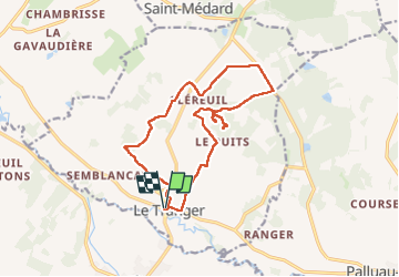

Length
15.1 km

Max alt
178 m

Uphill gradient
228 m
Km-Effort
18.1 km

Min alt
93 m

Downhill gradient
228 m
Boucle
Yes
Creation date :
2024-07-05 07:39:31.907
Updated on :
2024-07-05 13:21:31.067
3h32
Difficulty : Difficult

FREE GPS app for hiking
 SityTrail
IGN / Geographical institutes
SityTrail Plus
The world is yours!
About
Trail Walking of 15.1 km to be discovered at Centre-Loire Valley, Indre, Le Tranger. This trail is proposed by Dupuybadonniere.
Positioning
Country:
France
Region :
Centre-Loire Valley
Department/Province :
Indre
Municipality :
Le Tranger
Location:
Unknown
Start:(Dec)
Start:(UTM)
366050 ; 5201920 (31T) N.
Comments