


05-og-lac

Jack-94
User
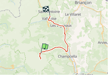

Length
38 km

Max alt
2003 m

Uphill gradient
1035 m
Km-Effort
53 km

Min alt
938 m

Downhill gradient
1247 m
Boucle
No
Creation date :
2024-07-05 07:41:32.261
Updated on :
2024-07-05 15:03:00.083
7h20
Difficulty : Very difficult

FREE GPS app for hiking
 SityTrail
IGN / Geographical institutes
SityTrail Plus
The world is yours!
About
Trail Walking of 38 km to be discovered at Provence-Alpes-Côte d'Azur, Hautes-Alpes, Freissinières. This trail is proposed by Jack-94.
Positioning
Country:
France
Region :
Provence-Alpes-Côte d'Azur
Department/Province :
Hautes-Alpes
Municipality :
Freissinières
Location:
Unknown
Start:(Dec)
Start:(UTM)
298061 ; 4956506 (32T) N.
Comments