


le tour de NEVACHE 2

okfred26
User
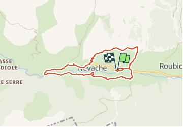

Length
7.8 km

Max alt
1719 m

Uphill gradient
247 m
Km-Effort
11.1 km

Min alt
1586 m

Downhill gradient
246 m
Boucle
Yes
Creation date :
2024-07-05 18:23:03.205
Updated on :
2024-07-05 18:22:41.364
2h31
Difficulty : Medium

FREE GPS app for hiking
 SityTrail
IGN / Geographical institutes
SityTrail Plus
The world is yours!
About
Trail Walking of 7.8 km to be discovered at Provence-Alpes-Côte d'Azur, Hautes-Alpes, Névache. This trail is proposed by okfred26.
Positioning
Country:
France
Region :
Provence-Alpes-Côte d'Azur
Department/Province :
Hautes-Alpes
Municipality :
Névache
Location:
Unknown
Start:(Dec)
Start:(UTM)
311920 ; 4987770 (32T) N.
Comments