


bois de belvedere au depart de chamarande

tyjibreizh
User
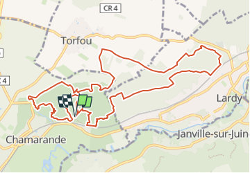

Length
12.6 km

Max alt
162 m

Uphill gradient
342 m
Km-Effort
17.2 km

Min alt
81 m

Downhill gradient
342 m
Boucle
Yes
Creation date :
2024-07-06 09:24:37.539
Updated on :
2024-07-06 09:34:53.606
3h54
Difficulty : Difficult

FREE GPS app for hiking
 SityTrail
IGN / Geographical institutes
SityTrail Plus
The world is yours!
About
Trail Walking of 12.6 km to be discovered at Ile-de-France, Essonne, Chamarande. This trail is proposed by tyjibreizh .
Description
bois de belvedere et boucle vers torfou
Positioning
Country:
France
Region :
Ile-de-France
Department/Province :
Essonne
Municipality :
Chamarande
Location:
Unknown
Start:(Dec)
Start:(UTM)
442947 ; 5374088 (31U) N.
Comments