


leclerc a la taulette

NESTOR2714
User
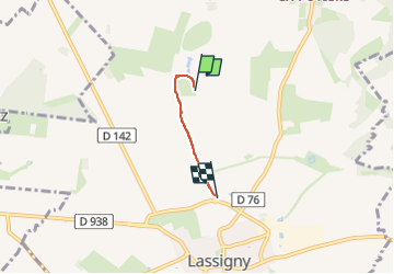

Length
1.9 km

Max alt
86 m

Uphill gradient
5 m
Km-Effort
2 km

Min alt
60 m

Downhill gradient
24 m
Boucle
No
Creation date :
2024-07-06 14:24:24.181
Updated on :
2024-07-06 15:01:13.021
35m
Difficulty : Easy

FREE GPS app for hiking
 SityTrail
IGN / Geographical institutes
SityTrail Plus
The world is yours!
About
Trail Walking of 1.9 km to be discovered at Hauts-de-France, Oise, Lassigny. This trail is proposed by NESTOR2714.
Description
aller seul 2 km
Photos


Positioning
Country:
France
Region :
Hauts-de-France
Department/Province :
Oise
Municipality :
Lassigny
Location:
Unknown
Start:(Dec)
Start:(UTM)
488377 ; 5494759 (31U) N.
Comments