


Bellebouche étang

Dupuybadonniere
User
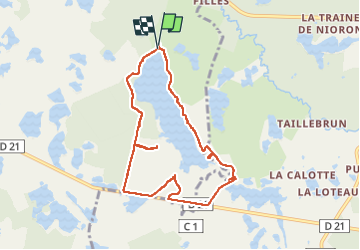

Length
8 km

Max alt
115 m

Uphill gradient
45 m
Km-Effort
8.6 km

Min alt
104 m

Downhill gradient
43 m
Boucle
Yes
Creation date :
2024-07-07 07:18:45.701
Updated on :
2024-07-07 09:49:13.652
1h58
Difficulty : Medium

FREE GPS app for hiking
 SityTrail
IGN / Geographical institutes
SityTrail Plus
The world is yours!
About
Trail Walking of 8 km to be discovered at Centre-Loire Valley, Indre, Mézières-en-Brenne. This trail is proposed by Dupuybadonniere.
Positioning
Country:
France
Region :
Centre-Loire Valley
Department/Province :
Indre
Municipality :
Mézières-en-Brenne
Location:
Unknown
Start:(Dec)
Start:(UTM)
370660 ; 5184144 (31T) N.
Comments