


GTJ étape 1

lorenzot54
User
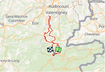

Length
59 km

Max alt
835 m

Uphill gradient
1688 m
Km-Effort
81 km

Min alt
332 m

Downhill gradient
1688 m
Boucle
Yes
Creation date :
2024-07-07 07:39:17.0
Updated on :
2024-07-07 15:15:30.95

FREE GPS app for hiking
 SityTrail
IGN / Geographical institutes
SityTrail Plus
The world is yours!
About
Trail of 59 km to be discovered at Bourgogne-Franche-Comté, Doubs, Saint-Hippolyte. This trail is proposed by lorenzot54.
Positioning
Country:
France
Region :
Bourgogne-Franche-Comté
Department/Province :
Doubs
Municipality :
Saint-Hippolyte
Location:
Unknown
Start:(Dec)
Start:(UTM)
335331 ; 5243180 (32T) N.
Comments