


la daille

jojo02
User
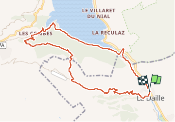

Length
11.9 km

Max alt
2251 m

Uphill gradient
646 m
Km-Effort
21 km

Min alt
1763 m

Downhill gradient
646 m
Boucle
Yes
Creation date :
2024-07-09 08:19:56.214
Updated on :
2024-07-09 12:56:49.429
4h35
Difficulty : Very difficult

FREE GPS app for hiking
 SityTrail
IGN / Geographical institutes
SityTrail Plus
The world is yours!
About
Trail Walking of 11.9 km to be discovered at Auvergne-Rhône-Alpes, Savoy, Val-d'Isère. This trail is proposed by jojo02.
Positioning
Country:
France
Region :
Auvergne-Rhône-Alpes
Department/Province :
Savoy
Municipality :
Val-d'Isère
Location:
Unknown
Start:(Dec)
Start:(UTM)
340868 ; 5036298 (32T) N.
Comments