


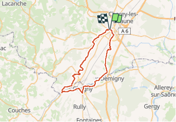
La ”Voie des Vignes” et la ”Voie des Étangs”

micheldutilleul
User

Length
49 km

Max alt
294 m

Uphill gradient
384 m
Km-Effort
54 km

Min alt
192 m

Downhill gradient
384 m
Boucle
Yes
Creation date :
2024-07-09 08:12:35.281
Updated on :
2024-07-09 16:17:40.467
4h54
Difficulty : Easy

FREE GPS app for hiking
 SityTrail
IGN / Geographical institutes
SityTrail Plus
The world is yours!
About
Trail Electric bike of 49 km to be discovered at Bourgogne-Franche-Comté, Côte-d'Or, Beaune. This trail is proposed by micheldutilleul.
Description
De Beaune à Beaune : Suivre la "Voie des Vignes" de Beaune à Santenay; de Santenay à Chagny longer le Canal du Centre; de Chagny vers Beaune, suivre la "Voie des Etangs”
Positioning
Country:
France
Region :
Bourgogne-Franche-Comté
Department/Province :
Côte-d'Or
Municipality :
Beaune
Location:
Unknown
Start:(Dec)
Start:(UTM)
638988 ; 5209675 (31T) N.
Comments