


09-og-refuge

Jack-94
User
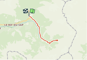

Length
12.5 km

Max alt
2153 m

Uphill gradient
644 m
Km-Effort
21 km

Min alt
1547 m

Downhill gradient
646 m
Boucle
Yes
Creation date :
2024-07-09 07:06:02.364
Updated on :
2024-07-09 17:05:48.675
9h58
Difficulty : Very difficult

FREE GPS app for hiking
 SityTrail
IGN / Geographical institutes
SityTrail Plus
The world is yours!
About
Trail Walking of 12.5 km to be discovered at Provence-Alpes-Côte d'Azur, Hautes-Alpes, La Chapelle-en-Valgaudémar. This trail is proposed by Jack-94.
Positioning
Country:
France
Region :
Provence-Alpes-Côte d'Azur
Department/Province :
Hautes-Alpes
Municipality :
La Chapelle-en-Valgaudémar
Location:
Unknown
Start:(Dec)
Start:(UTM)
285203 ; 4968247 (32T) N.
Comments