


11-jg-tiriere

Jack-94
User
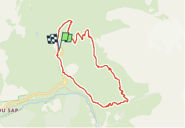

Length
9.9 km

Max alt
2239 m

Uphill gradient
720 m
Km-Effort
19.5 km

Min alt
1547 m

Downhill gradient
718 m
Boucle
Yes
Creation date :
2024-07-11 07:11:04.747
Updated on :
2024-07-11 14:49:23.992
7h37
Difficulty : Very difficult

FREE GPS app for hiking
 SityTrail
IGN / Geographical institutes
SityTrail Plus
The world is yours!
About
Trail Walking of 9.9 km to be discovered at Provence-Alpes-Côte d'Azur, Hautes-Alpes, La Chapelle-en-Valgaudémar. This trail is proposed by Jack-94.
Positioning
Country:
France
Region :
Provence-Alpes-Côte d'Azur
Department/Province :
Hautes-Alpes
Municipality :
La Chapelle-en-Valgaudémar
Location:
Unknown
Start:(Dec)
Start:(UTM)
285147 ; 4968913 (32T) N.
Comments