


Combeau

raygautier
User
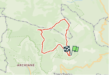

Length
14.4 km

Max alt
1959 m

Uphill gradient
803 m
Km-Effort
25 km

Min alt
1306 m

Downhill gradient
802 m
Boucle
Yes
Creation date :
2024-07-11 06:19:09.0
Updated on :
2024-07-11 17:57:28.957

FREE GPS app for hiking
 SityTrail
IGN / Geographical institutes
SityTrail Plus
The world is yours!
About
Trail of 14.4 km to be discovered at Auvergne-Rhône-Alpes, Drôme, Châtillon-en-Diois. This trail is proposed by raygautier.
Positioning
Country:
France
Region :
Auvergne-Rhône-Alpes
Department/Province :
Drôme
Municipality :
Châtillon-en-Diois
Location:
Treschenu-Creyers
Start:(Dec)
Start:(UTM)
702354 ; 4958794 (31T) N.
Comments