


Monté Gsang

MAD-CVW
User
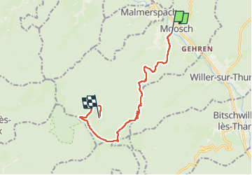

Length
10.6 km

Max alt
1170 m

Uphill gradient
805 m
Km-Effort
19.2 km

Min alt
386 m

Downhill gradient
166 m
Boucle
No
Creation date :
2024-07-12 07:41:24.889
Updated on :
2024-07-12 12:41:56.315
3h07
Difficulty : Very difficult

FREE GPS app for hiking
 SityTrail
IGN / Geographical institutes
SityTrail Plus
The world is yours!
About
Trail Walking of 10.6 km to be discovered at Grand Est, Haut-Rhin, Moosch. This trail is proposed by MAD-CVW.
Positioning
Country:
France
Region :
Grand Est
Department/Province :
Haut-Rhin
Municipality :
Moosch
Location:
Unknown
Start:(Dec)
Start:(UTM)
353871 ; 5302383 (32T) N.
Comments