


Boucle Mijoux, Lajoux, Moussieres,Lelex,Moront

cyrghe
User
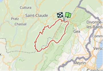

Length
57 km

Max alt
1683 m

Uphill gradient
2263 m
Km-Effort
87 km

Min alt
849 m

Downhill gradient
2261 m
Boucle
Yes
Creation date :
2024-07-12 09:47:50.0
Updated on :
2024-07-14 16:15:55.265
18h56
Difficulty : Unknown

FREE GPS app for hiking
 SityTrail
IGN / Geographical institutes
SityTrail Plus
The world is yours!
About
Trail Walking of 57 km to be discovered at Auvergne-Rhône-Alpes, Ain, Mijoux. This trail is proposed by cyrghe.
Description
Belle randonnée en partie sur les crêtes
Positioning
Country:
France
Region :
Auvergne-Rhône-Alpes
Department/Province :
Ain
Municipality :
Mijoux
Location:
Unknown
Start:(Dec)
Start:(UTM)
730477 ; 5139118 (31T) N.
Comments