


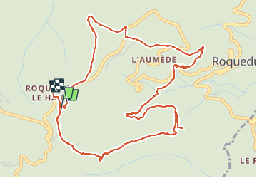
Roquedur le haut

inesmyt
User

Length
7.3 km

Max alt
622 m

Uphill gradient
299 m
Km-Effort
11.3 km

Min alt
351 m

Downhill gradient
301 m
Boucle
Yes
Creation date :
2024-07-15 13:51:39.161
Updated on :
2024-07-15 15:40:08.557
1h38
Difficulty : Medium

FREE GPS app for hiking
 SityTrail
IGN / Geographical institutes
SityTrail Plus
The world is yours!
About
Trail Walking of 7.3 km to be discovered at Occitania, Gard, Roquedur. This trail is proposed by inesmyt.
Positioning
Country:
France
Region :
Occitania
Department/Province :
Gard
Municipality :
Roquedur
Location:
Unknown
Start:(Dec)
Start:(UTM)
552770 ; 4869057 (31T) N.
Comments