


J2.Hinterzarten-Todtnauer hutte

vtaquin
User
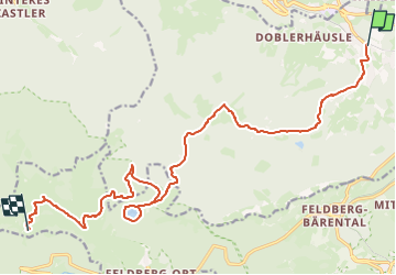

Length
17.5 km

Max alt
1493 m

Uphill gradient
778 m
Km-Effort
26 km

Min alt
882 m

Downhill gradient
343 m
Boucle
No
Creation date :
2024-07-16 14:51:14.907
Updated on :
2024-07-16 14:51:36.302
6h00
Difficulty : Very difficult

FREE GPS app for hiking
 SityTrail
IGN / Geographical institutes
SityTrail Plus
The world is yours!
About
Trail Walking of 17.5 km to be discovered at Baden-Württemberg, Landkreis Breisgau-Hochschwarzwald, Hinterzarten. This trail is proposed by vtaquin.
Positioning
Country:
Germany
Region :
Baden-Württemberg
Department/Province :
Landkreis Breisgau-Hochschwarzwald
Municipality :
Hinterzarten
Location:
Unknown
Start:(Dec)
Start:(UTM)
433172 ; 5306211 (32T) N.
Comments