


2024 zap ecrins

ISAGIL
User
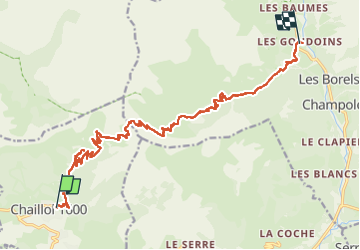

Length
19.4 km

Max alt
2489 m

Uphill gradient
1012 m
Km-Effort
34 km

Min alt
1300 m

Downhill gradient
1311 m
Boucle
No
Creation date :
2024-07-16 06:59:59.371
Updated on :
2024-07-16 15:59:31.858
7h51
Difficulty : Very difficult

FREE GPS app for hiking
 SityTrail
IGN / Geographical institutes
SityTrail Plus
The world is yours!
About
Trail Walking of 19.4 km to be discovered at Provence-Alpes-Côte d'Azur, Hautes-Alpes, Saint-Michel-de-Chaillol. This trail is proposed by ISAGIL.
Description
vers les gaudoins
Positioning
Country:
France
Region :
Provence-Alpes-Côte d'Azur
Department/Province :
Hautes-Alpes
Municipality :
Saint-Michel-de-Chaillol
Location:
Unknown
Start:(Dec)
Start:(UTM)
275447 ; 4952290 (32T) N.
Comments