


Rando lacs de Meudon 21km

jeanmarcMasson
User GUIDE
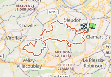

Length
21 km

Max alt
186 m

Uphill gradient
437 m
Km-Effort
27 km

Min alt
80 m

Downhill gradient
439 m
Boucle
Yes
Creation date :
2024-07-17 08:11:03.535
Updated on :
2024-07-17 14:13:53.27
4h40
Difficulty : Very difficult

FREE GPS app for hiking
 SityTrail
IGN / Geographical institutes
SityTrail Plus
The world is yours!
About
Trail Walking of 21 km to be discovered at Ile-de-France, Hauts-de-Seine, Clamart. This trail is proposed by jeanmarcMasson.
Positioning
Country:
France
Region :
Ile-de-France
Department/Province :
Hauts-de-Seine
Municipality :
Clamart
Location:
Unknown
Start:(Dec)
Start:(UTM)
445340 ; 5405849 (31U) N.
Comments