


2024 07 Breux t1

michel1025
User
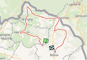

Length
15.9 km

Max alt
320 m

Uphill gradient
275 m
Km-Effort
19.7 km

Min alt
203 m

Downhill gradient
304 m
Boucle
No
Creation date :
2024-07-18 12:35:24.0
Updated on :
2024-07-18 16:05:26.531
3h29
Difficulty : Very difficult

FREE GPS app for hiking
 SityTrail
IGN / Geographical institutes
SityTrail Plus
The world is yours!
About
Trail Walking of 15.9 km to be discovered at Grand Est, Meuse, Breux. This trail is proposed by michel1025.
Positioning
Country:
France
Region :
Grand Est
Department/Province :
Meuse
Municipality :
Breux
Location:
Unknown
Start:(Dec)
Start:(UTM)
671459 ; 5495797 (31U) N.
Comments