


2024 zap valonpierre

ISAGIL
User
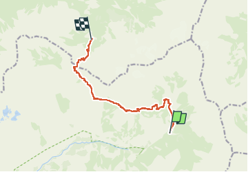

Length
11.4 km

Max alt
2667 m

Uphill gradient
1149 m
Km-Effort
25 km

Min alt
1803 m

Downhill gradient
675 m
Boucle
No
Creation date :
2024-07-18 05:55:17.162
Updated on :
2024-07-20 07:43:54.658
6h57
Difficulty : Very difficult

FREE GPS app for hiking
 SityTrail
IGN / Geographical institutes
SityTrail Plus
The world is yours!
About
Trail Walking of 11.4 km to be discovered at Provence-Alpes-Côte d'Azur, Hautes-Alpes, Champoléon. This trail is proposed by ISAGIL.
Positioning
Country:
France
Region :
Provence-Alpes-Côte d'Azur
Department/Province :
Hautes-Alpes
Municipality :
Champoléon
Location:
Unknown
Start:(Dec)
Start:(UTM)
288527 ; 4960356 (32T) N.
Comments