


2024 07 Mouzay t1

michel1025
User
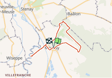

Length
12.7 km

Max alt
251 m

Uphill gradient
117 m
Km-Effort
14.3 km

Min alt
163 m

Downhill gradient
119 m
Boucle
Yes
Creation date :
2024-07-20 11:31:57.0
Updated on :
2024-07-20 14:25:46.378
2h53
Difficulty : Difficult

FREE GPS app for hiking
 SityTrail
IGN / Geographical institutes
SityTrail Plus
The world is yours!
About
Trail Walking of 12.7 km to be discovered at Grand Est, Meuse, Mouzay. This trail is proposed by michel1025.
Positioning
Country:
France
Region :
Grand Est
Department/Province :
Meuse
Municipality :
Mouzay
Location:
Unknown
Start:(Dec)
Start:(UTM)
660705 ; 5481356 (31U) N.
Comments