Gisors ses monuments ses rivières

serge.guerroult
User
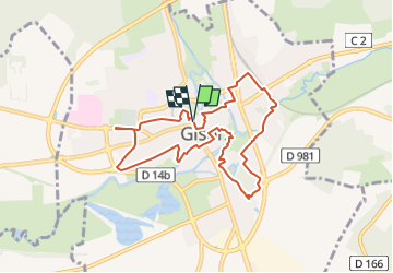

Length
8.1 km

Max alt
79 m

Uphill gradient
67 m
Km-Effort
9 km

Min alt
49 m

Downhill gradient
72 m
Boucle
Yes
Creation date :
2024-07-21 08:28:11.889
Updated on :
2024-07-22 06:12:45.431
1h59
Difficulty : Medium

FREE GPS app for hiking
 SityTrail
IGN / Geographical institutes
SityTrail Plus
The world is yours!
About
Trail Walking of 8.1 km to be discovered at Normandy, Eure, Gisors. This trail is proposed by serge.guerroult.
Positioning
Country:
France
Region :
Normandy
Department/Province :
Eure
Municipality :
Gisors
Location:
Unknown
Start:(Dec)
Start:(UTM)
410968 ; 5459332 (31U) N.
Comments