


Cerfontaine variante circuit Ostergnies

mjh
User
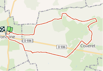

Length
10.5 km

Max alt
200 m

Uphill gradient
117 m
Km-Effort
12 km

Min alt
146 m

Downhill gradient
119 m
Boucle
Yes
Creation date :
2024-07-21 11:30:26.888
Updated on :
2024-07-21 14:11:07.471
2h28
Difficulty : Easy

FREE GPS app for hiking
 SityTrail
IGN / Geographical institutes
SityTrail Plus
The world is yours!
About
Trail Walking of 10.5 km to be discovered at Hauts-de-France, Nord, Cerfontaine. This trail is proposed by mjh.
Photos

Positioning
Country:
France
Region :
Hauts-de-France
Department/Province :
Nord
Municipality :
Cerfontaine
Location:
Unknown
Start:(Dec)
Start:(UTM)
573152 ; 5568068 (31U) N.
Comments