


23 juillet

arnoultjf
User
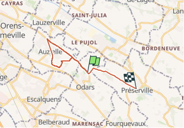

Length
10.4 km

Max alt
230 m

Uphill gradient
156 m
Km-Effort
12.2 km

Min alt
158 m

Downhill gradient
94 m
Boucle
No
Creation date :
2024-07-23 07:18:23.853
Updated on :
2024-07-23 09:38:19.951
1h47
Difficulty : Difficult

FREE GPS app for hiking
 SityTrail
IGN / Geographical institutes
SityTrail Plus
The world is yours!
About
Trail Walking of 10.4 km to be discovered at Occitania, Haute-Garonne, Odars. This trail is proposed by arnoultjf.
Photos


Positioning
Country:
France
Region :
Occitania
Department/Province :
Haute-Garonne
Municipality :
Odars
Location:
Unknown
Start:(Dec)
Start:(UTM)
386188 ; 4820795 (31T) N.
Comments