


M

raygautier
User

Length
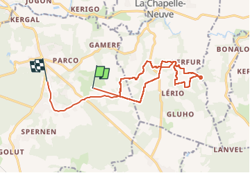
16.1 km

Max alt
130 m

Uphill gradient
250 m
Km-Effort
19.4 km

Min alt
62 m

Downhill gradient
237 m
Boucle
No
Creation date :
2024-07-23 06:59:33.0
Updated on :
2024-07-23 09:58:56.304

FREE GPS app for hiking
 SityTrail
IGN / Geographical institutes
SityTrail Plus
The world is yours!
About
Trail of 16.1 km to be discovered at Brittany, Morbihan, Camors. This trail is proposed by raygautier.
Photos

Positioning
Country:
France
Region :
Brittany
Department/Province :
Morbihan
Municipality :
Camors
Location:
Unknown
Start:(Dec)
Start:(UTM)
501839 ; 5298286 (30T) N.
Comments