


Boucle de Bonifatu

Alouest31
User
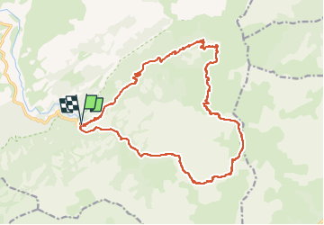

Length
22 km

Max alt
2055 m

Uphill gradient
1747 m
Km-Effort
45 km

Min alt
502 m

Downhill gradient
1744 m
Boucle
Yes
Creation date :
2024-07-23 11:23:43.0
Updated on :
2024-07-23 11:23:44.98
6h00
Difficulty : Medium

FREE GPS app for hiking
 SityTrail
IGN / Geographical institutes
SityTrail Plus
The world is yours!
About
Trail Trail of 22 km to be discovered at Corsica, Haute-Corse, Calenzana. This trail is proposed by Alouest31.
Positioning
Country:
France
Region :
Corsica
Department/Province :
Haute-Corse
Municipality :
Calenzana
Location:
Unknown
Start:(Dec)
Start:(UTM)
488090 ; 4698969 (32T) N.
Comments