


le landard 23 juillet

pierrounet
User
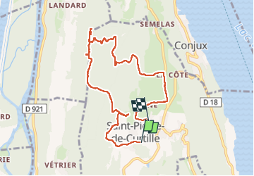

Length
9.3 km

Max alt
591 m

Uphill gradient
349 m
Km-Effort
14 km

Min alt
375 m

Downhill gradient
372 m
Boucle
No
Creation date :
2024-07-23 08:00:33.749
Updated on :
2024-07-23 12:15:07.484
4h14
Difficulty : Difficult

FREE GPS app for hiking
 SityTrail
IGN / Geographical institutes
SityTrail Plus
The world is yours!
About
Trail Walking of 9.3 km to be discovered at Auvergne-Rhône-Alpes, Savoy, Saint-Pierre-de-Curtille. This trail is proposed by pierrounet.
Positioning
Country:
France
Region :
Auvergne-Rhône-Alpes
Department/Province :
Savoy
Municipality :
Saint-Pierre-de-Curtille
Location:
Unknown
Start:(Dec)
Start:(UTM)
718432 ; 5072715 (31T) N.
Comments