


aigoual via cabrillac

labarone
User
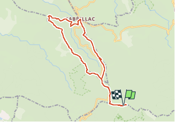

Length
19.1 km

Max alt
1562 m

Uphill gradient
601 m
Km-Effort
27 km

Min alt
1169 m

Downhill gradient
603 m
Boucle
Yes
Creation date :
2024-07-23 07:31:33.087
Updated on :
2024-07-23 13:43:27.953
6h10
Difficulty : Easy

FREE GPS app for hiking
 SityTrail
IGN / Geographical institutes
SityTrail Plus
The world is yours!
About
Trail Walking of 19.1 km to be discovered at Occitania, Gard, Val-d'Aigoual. This trail is proposed by labarone.
Description
sympa
une petite côte sur le retour
Positioning
Country:
France
Region :
Occitania
Department/Province :
Gard
Municipality :
Val-d'Aigoual
Location:
Valleraugue
Start:(Dec)
Start:(UTM)
546403 ; 4885516 (31T) N.
Comments