


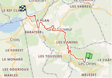
descente depuis les Orres en vtt

guariso
User

Length
11.5 km

Max alt
1475 m

Uphill gradient
96 m
Km-Effort
15 km

Min alt
782 m

Downhill gradient
782 m
Boucle
No
Creation date :
2024-07-23 12:36:24.066
Updated on :
2024-07-23 15:22:05.519
2h44
Difficulty : Difficult

FREE GPS app for hiking
 SityTrail
IGN / Geographical institutes
SityTrail Plus
The world is yours!
About
Trail Mountain bike of 11.5 km to be discovered at Provence-Alpes-Côte d'Azur, Hautes-Alpes, Les Orres. This trail is proposed by guariso.
Description
Attention pas une descente à la portée des débutants, ce n'est pas une boucle.
Positioning
Country:
France
Region :
Provence-Alpes-Côte d'Azur
Department/Province :
Hautes-Alpes
Municipality :
Les Orres
Location:
Unknown
Start:(Dec)
Start:(UTM)
305125 ; 4931969 (32T) N.
Comments