


les 2 vallées sous la mousse ...

stef789
User GUIDE

Length
12.2 km

Max alt
492 m

Uphill gradient
415 m
Km-Effort
17.8 km

Min alt
310 m

Downhill gradient
417 m
Boucle
Yes
Creation date :
2024-07-23 10:40:18.486
Updated on :
2024-07-23 16:06:35.043
4h13
Difficulty : Medium

FREE GPS app for hiking
 SityTrail
IGN / Geographical institutes
SityTrail Plus
The world is yours!
About
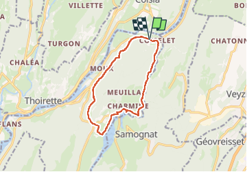
Trail Walking of 12.2 km to be discovered at Auvergne-Rhône-Alpes, Ain, Matafelon-Granges. This trail is proposed by stef789.
Photos


40 photos in total. Please click on a photo to see them all in the gallery.
Positioning
Country:
France
Region :
Auvergne-Rhône-Alpes
Department/Province :
Ain
Municipality :
Matafelon-Granges
Location:
Unknown
Start:(Dec)
Start:(UTM)
698922 ; 5129578 (31T) N.
Comments