


st die madeleine

ISAGIL
User
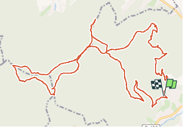

Length
18.1 km

Max alt
670 m

Uphill gradient
577 m
Km-Effort
26 km

Min alt
363 m

Downhill gradient
580 m
Boucle
Yes
Creation date :
2024-07-25 07:06:43.464
Updated on :
2024-07-25 15:06:42.229
6h31
Difficulty : Very difficult

FREE GPS app for hiking
 SityTrail
IGN / Geographical institutes
SityTrail Plus
The world is yours!
About
Trail Walking of 18.1 km to be discovered at Grand Est, Vosges, Saint-Dié-des-Vosges. This trail is proposed by ISAGIL.
Positioning
Country:
France
Region :
Grand Est
Department/Province :
Vosges
Municipality :
Saint-Dié-des-Vosges
Location:
Unknown
Start:(Dec)
Start:(UTM)
344831 ; 5350108 (32U) N.
Comments