


Plan de l'aiguille - Montenvers - V2 deniv +167m -572m

jeanmarcMasson
User GUIDE
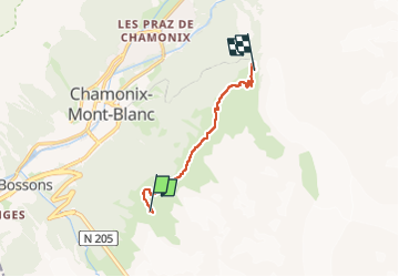

Length
6.9 km

Max alt
2316 m

Uphill gradient
167 m
Km-Effort
10.4 km

Min alt
1906 m

Downhill gradient
572 m
Boucle
No
Creation date :
2024-07-26 08:45:23.693
Updated on :
2024-07-26 10:01:21.447
2h22
Difficulty : Medium

FREE GPS app for hiking
 SityTrail
IGN / Geographical institutes
SityTrail Plus
The world is yours!
About
Trail Walking of 6.9 km to be discovered at Auvergne-Rhône-Alpes, Upper Savoy, Chamonix-Mont-Blanc. This trail is proposed by jeanmarcMasson.
Positioning
Country:
France
Region :
Auvergne-Rhône-Alpes
Department/Province :
Upper Savoy
Municipality :
Chamonix-Mont-Blanc
Location:
Unknown
Start:(Dec)
Start:(UTM)
335934 ; 5085276 (32T) N.
Comments