


La flégère - Refuge du lac blanc deniv +516m

jeanmarcMasson
User GUIDE
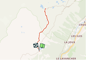

Length
6.2 km

Max alt
2359 m

Uphill gradient
516 m
Km-Effort
13 km

Min alt
1859 m

Downhill gradient
508 m
Boucle
Yes
Creation date :
2024-07-26 09:38:55.721
Updated on :
2024-07-26 10:05:13.114
2h57
Difficulty : Difficult

FREE GPS app for hiking
 SityTrail
IGN / Geographical institutes
SityTrail Plus
The world is yours!
About
Trail Walking of 6.2 km to be discovered at Auvergne-Rhône-Alpes, Upper Savoy, Chamonix-Mont-Blanc. This trail is proposed by jeanmarcMasson.
Positioning
Country:
France
Region :
Auvergne-Rhône-Alpes
Department/Province :
Upper Savoy
Municipality :
Chamonix-Mont-Blanc
Location:
Unknown
Start:(Dec)
Start:(UTM)
336271 ; 5091807 (32T) N.
Comments