


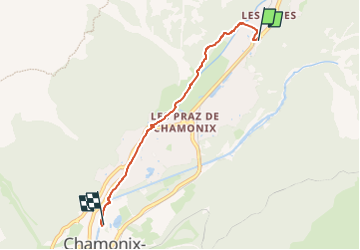
Les Tines - Piscine Chamonix - 4 km

jeanmarcMasson
User GUIDE

Length
4.1 km

Max alt
1103 m

Uphill gradient
27 m
Km-Effort
4.6 km

Min alt
1040 m

Downhill gradient
72 m
Boucle
No
Creation date :
2024-07-26 09:56:37.011
Updated on :
2024-07-26 09:58:36.628
1h02
Difficulty : Easy

FREE GPS app for hiking
 SityTrail
IGN / Geographical institutes
SityTrail Plus
The world is yours!
About
Trail Walking of 4.1 km to be discovered at Auvergne-Rhône-Alpes, Upper Savoy, Chamonix-Mont-Blanc. This trail is proposed by jeanmarcMasson.
Positioning
Country:
France
Region :
Auvergne-Rhône-Alpes
Department/Province :
Upper Savoy
Municipality :
Chamonix-Mont-Blanc
Location:
Unknown
Start:(Dec)
Start:(UTM)
337194 ; 5090684 (32T) N.
Comments