


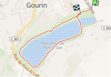
Gourin le Tour du plan d'eau.

MichelRando7656
User

Length
1 km

Max alt
134 m

Uphill gradient
7 m
Km-Effort
1.1 km

Min alt
126 m

Downhill gradient
6 m
Boucle
Yes
Creation date :
2024-07-26 16:18:20.846
Updated on :
2024-07-26 16:56:35.964
37m
Difficulty : Easy

FREE GPS app for hiking
 SityTrail
IGN / Geographical institutes
SityTrail Plus
The world is yours!
About
Trail Walking of 1 km to be discovered at Brittany, Morbihan, Gourin. This trail is proposed by MichelRando7656.
Description
Petite promenade reposante au bord de l'eau
Photos


Positioning
Country:
France
Region :
Brittany
Department/Province :
Morbihan
Municipality :
Gourin
Location:
Unknown
Start:(Dec)
Start:(UTM)
455332 ; 5331854 (30U) N.
Comments