


te Croix

rosemarie
User
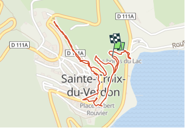

Length
1.4 km

Max alt
553 m

Uphill gradient
51 m
Km-Effort
2.1 km

Min alt
482 m

Downhill gradient
62 m
Boucle
Yes
Creation date :
2024-07-27 16:16:20.051
Updated on :
2024-07-27 17:42:47.671
30m
Difficulty : Easy

FREE GPS app for hiking
 SityTrail
IGN / Geographical institutes
SityTrail Plus
The world is yours!
About
Trail Walking of 1.4 km to be discovered at Provence-Alpes-Côte d'Azur, Alpes-de-Haute-Provence, Sainte-Croix-du-Verdon. This trail is proposed by rosemarie.
Positioning
Country:
France
Region :
Provence-Alpes-Côte d'Azur
Department/Province :
Alpes-de-Haute-Provence
Municipality :
Sainte-Croix-du-Verdon
Location:
Unknown
Start:(Dec)
Start:(UTM)
270790 ; 4849137 (32T) N.
Comments