


eyguoire Savines mix 25 et 11

guariso
User
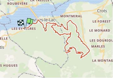

Length
27 km

Max alt
1646 m

Uphill gradient
1117 m
Km-Effort
42 km

Min alt
785 m

Downhill gradient
1097 m
Boucle
Yes
Creation date :
2024-07-28 07:29:35.645
Updated on :
2024-07-28 10:19:08.483
2h42
Difficulty : Very difficult

FREE GPS app for hiking
 SityTrail
IGN / Geographical institutes
SityTrail Plus
The world is yours!
About
Trail Mountain bike of 27 km to be discovered at Provence-Alpes-Côte d'Azur, Hautes-Alpes, Savines-le-Lac. This trail is proposed by guariso.
Description
Circuit en montée sur chemin forestier, descente en singles pentus et techniques
Positioning
Country:
France
Region :
Provence-Alpes-Côte d'Azur
Department/Province :
Hautes-Alpes
Municipality :
Savines-le-Lac
Location:
Unknown
Start:(Dec)
Start:(UTM)
292351 ; 4932865 (32T) N.
Comments