


Randonnée forêt noire schnaps

patign
User

Length
14.5 km

Max alt
486 m

Uphill gradient
466 m
Km-Effort
21 km

Min alt
196 m

Downhill gradient
466 m
Boucle
Yes
Creation date :
2024-07-28 08:53:33.0
Updated on :
2024-07-28 15:29:11.039
3h36
Difficulty : Unknown

FREE GPS app for hiking
 SityTrail
IGN / Geographical institutes
SityTrail Plus
The world is yours!
About
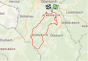
Trail Walking of 14.5 km to be discovered at Baden-Württemberg, Ortenaukreis, Oberkirch. This trail is proposed by patign.
Photos

Positioning
Country:
Germany
Region :
Baden-Württemberg
Department/Province :
Ortenaukreis
Municipality :
Oberkirch
Location:
Unknown
Start:(Dec)
Start:(UTM)
432287 ; 5374544 (32U) N.
Comments