


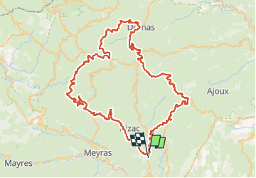
Vals Sagnes Bornas La Fayolle

thonyc
User GUIDE

Length
109 km

Max alt
1372 m

Uphill gradient
2577 m
Km-Effort
143 km

Min alt
276 m

Downhill gradient
2573 m
Boucle
No
Creation date :
2024-07-29 12:28:57.668
Updated on :
2024-07-30 16:37:47.695
8h41
Difficulty : Very difficult

FREE GPS app for hiking
 SityTrail
IGN / Geographical institutes
SityTrail Plus
The world is yours!
About
Trail Road bike of 109 km to be discovered at Auvergne-Rhône-Alpes, Ardèche, Vals-les-Bains. This trail is proposed by thonyc.
Positioning
Country:
France
Region :
Auvergne-Rhône-Alpes
Department/Province :
Ardèche
Municipality :
Vals-les-Bains
Location:
Unknown
Start:(Dec)
Start:(UTM)
608219 ; 4947633 (31T) N.
Comments