


240725 Resteigne

guy284
User
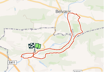

Length
8.9 km

Max alt
287 m

Uphill gradient
200 m
Km-Effort
11.5 km

Min alt
169 m

Downhill gradient
202 m
Boucle
Yes
Creation date :
2024-07-25 11:25:34.149
Updated on :
2024-07-29 15:35:45.157
2h17
Difficulty : Medium

FREE GPS app for hiking
 SityTrail
IGN / Geographical institutes
SityTrail Plus
The world is yours!
About
Trail Walking of 8.9 km to be discovered at Wallonia, Luxembourg, Tellin. This trail is proposed by guy284.
Positioning
Country:
Belgium
Region :
Wallonia
Department/Province :
Luxembourg
Municipality :
Tellin
Location:
Unknown
Start:(Dec)
Start:(UTM)
655648 ; 5551035 (31U) N.
Comments