


Circuit 1 raccourci

PhilippeC54
User
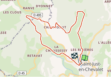

Length
10.1 km

Max alt
773 m

Uphill gradient
328 m
Km-Effort
14.5 km

Min alt
604 m

Downhill gradient
326 m
Boucle
Yes
Creation date :
2024-07-29 12:53:45.223
Updated on :
2024-07-29 15:42:34.98
2h36
Difficulty : Medium

FREE GPS app for hiking
 SityTrail
IGN / Geographical institutes
SityTrail Plus
The world is yours!
About
Trail Walking of 10.1 km to be discovered at Auvergne-Rhône-Alpes, Loire, Saint-Just-en-Chevalet. This trail is proposed by PhilippeC54.
Positioning
Country:
France
Region :
Auvergne-Rhône-Alpes
Department/Province :
Loire
Municipality :
Saint-Just-en-Chevalet
Location:
Unknown
Start:(Dec)
Start:(UTM)
565190 ; 5084892 (31T) N.
Comments