


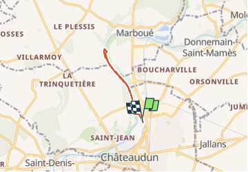
Kayak chateaudun
© OpenStreetMap contributors


1h59
Difficulty : Unknown


Length
6.6 km
Max alt
124 m
Uphill gradient
49 m
Km-Effort
7.3 km
Min alt
106 m
Downhill gradient
48 m
Boucle
Yes
Creation date :
2024-07-30 14:33:32.0
Updated on :
2024-07-30 16:33:37.62
1h59
Difficulty : Unknown
FREE GPS app for hiking
 SityTrail
IGN / Geographical institutes
SityTrail Plus
The world is yours!
About
Trail Canoe - kayak of 6.6 km to be discovered at Centre-Loire Valley, Eure-et-Loir, Châteaudun. This trail is proposed by 000549.ac9dea4f1351435185fde59f3be1c7e2.1846.
Positioning
Country:
France
Region :
Centre-Loire Valley
Department/Province :
Eure-et-Loir
Municipality :
Châteaudun
Location:
Unknown
Start:(Dec)
Start:(UTM)
375993 ; 5326845 (31U) N.
Comments