


Cols de St Thomas et de la Charme

PhilippeC54
User

Length
55 km

Max alt
1116 m

Uphill gradient
1401 m
Km-Effort
74 km

Min alt
594 m

Downhill gradient
1402 m
Boucle
Yes
Creation date :
2024-07-30 06:25:31.201
Updated on :
2024-07-30 20:15:08.915
3h37
Difficulty : Medium

FREE GPS app for hiking
 SityTrail
IGN / Geographical institutes
SityTrail Plus
The world is yours!
About
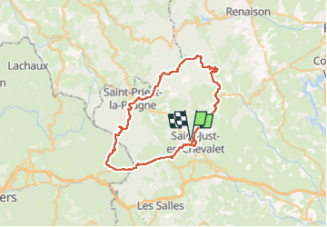
Trail Road bike of 55 km to be discovered at Auvergne-Rhône-Alpes, Loire, Saint-Just-en-Chevalet. This trail is proposed by PhilippeC54.
Positioning
Country:
France
Region :
Auvergne-Rhône-Alpes
Department/Province :
Loire
Municipality :
Saint-Just-en-Chevalet
Location:
Unknown
Start:(Dec)
Start:(UTM)
565117 ; 5085011 (31T) N.
Comments