


Col de Béal

PhilippeC54
User
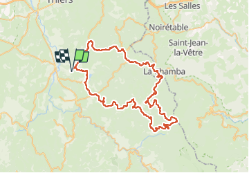

Length
78 km

Max alt
1407 m

Uphill gradient
1826 m
Km-Effort
102 km

Min alt
396 m

Downhill gradient
1826 m
Boucle
Yes
Creation date :
2024-08-03 07:02:52.539
Updated on :
2024-08-03 19:15:05.674
4h35
Difficulty : Very difficult

FREE GPS app for hiking
 SityTrail
IGN / Geographical institutes
SityTrail Plus
The world is yours!
About
Trail Road bike of 78 km to be discovered at Auvergne-Rhône-Alpes, Puy-de-Dôme, Aubusson-d'Auvergne. This trail is proposed by PhilippeC54.
Positioning
Country:
France
Region :
Auvergne-Rhône-Alpes
Department/Province :
Puy-de-Dôme
Municipality :
Aubusson-d'Auvergne
Location:
Unknown
Start:(Dec)
Start:(UTM)
544656 ; 5067043 (31T) N.
Comments