


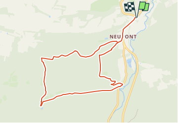
Boucle Halma-Neupont-Belvédère

xtislair
User

Length
9.4 km

Max alt
378 m

Uphill gradient
337 m
Km-Effort
13.9 km

Min alt
199 m

Downhill gradient
337 m
Boucle
Yes
Creation date :
2024-08-04 06:53:40.357
Updated on :
2024-08-04 06:54:30.972
3h09
Difficulty : Difficult

FREE GPS app for hiking
 SityTrail
IGN / Geographical institutes
SityTrail Plus
The world is yours!
About
Trail Walking of 9.4 km to be discovered at Wallonia, Luxembourg, Wellin. This trail is proposed by xtislair.
Positioning
Country:
Belgium
Region :
Wallonia
Department/Province :
Luxembourg
Municipality :
Wellin
Location:
Unknown
Start:(Dec)
Start:(UTM)
653274 ; 5548623 (31U) N.
Comments