


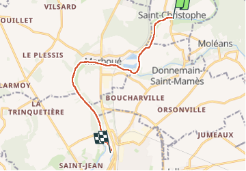
Kayak
© OpenStreetMap contributors


3h05
Difficulty : Unknown


Length
9.5 km
Max alt
124 m
Uphill gradient
59 m
Km-Effort
10.3 km
Min alt
106 m
Downhill gradient
67 m
Boucle
No
Creation date :
2024-08-04 13:47:09.0
Updated on :
2024-08-04 16:53:24.045
3h05
Difficulty : Unknown
FREE GPS app for hiking
 SityTrail
IGN / Geographical institutes
SityTrail Plus
The world is yours!
About
Trail Canoe - kayak of 9.5 km to be discovered at Centre-Loire Valley, Eure-et-Loir, Saint-Christophe. This trail is proposed by 000549.ac9dea4f1351435185fde59f3be1c7e2.1846.
Positioning
Country:
France
Region :
Centre-Loire Valley
Department/Province :
Eure-et-Loir
Municipality :
Saint-Christophe
Location:
Unknown
Start:(Dec)
Start:(UTM)
378447 ; 5331612 (31U) N.
Comments