


winennes - Vencimont

Dries Naulaers
User
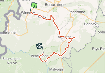

Length
23 km

Max alt
402 m

Uphill gradient
468 m
Km-Effort
30 km

Min alt
237 m

Downhill gradient
487 m
Boucle
No
Creation date :
2024-08-05 06:25:02.314
Updated on :
2024-08-05 11:49:05.901
4h35
Difficulty : Easy

FREE GPS app for hiking
 SityTrail
IGN / Geographical institutes
SityTrail Plus
The world is yours!
About
Trail Walking of 23 km to be discovered at Wallonia, Namur, Beauraing. This trail is proposed by Dries Naulaers.
Description
heel mooie wandeling
Positioning
Country:
Belgium
Region :
Wallonia
Department/Province :
Namur
Municipality :
Beauraing
Location:
Unknown
Start:(Dec)
Start:(UTM)
635764 ; 5551435 (31U) N.
Comments