


Les Tines -Le chapeau 8km 500m

jeanmarcMasson
User GUIDE
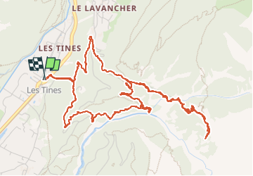

Length
8 km

Max alt
1587 m

Uphill gradient
519 m
Km-Effort
14.9 km

Min alt
1086 m

Downhill gradient
518 m
Boucle
Yes
Creation date :
2024-08-05 08:13:01.906
Updated on :
2024-08-05 12:41:32.979
2h44
Difficulty : Difficult

FREE GPS app for hiking
 SityTrail
IGN / Geographical institutes
SityTrail Plus
The world is yours!
About
Trail Walking of 8 km to be discovered at Auvergne-Rhône-Alpes, Upper Savoy, Chamonix-Mont-Blanc. This trail is proposed by jeanmarcMasson.
Positioning
Country:
France
Region :
Auvergne-Rhône-Alpes
Department/Province :
Upper Savoy
Municipality :
Chamonix-Mont-Blanc
Location:
Unknown
Start:(Dec)
Start:(UTM)
337172 ; 5090702 (32T) N.
Comments