


Col de la Molède et cascade Chambeuil

PhilippeC54
User
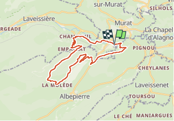

Length
16.8 km

Max alt
1337 m

Uphill gradient
699 m
Km-Effort
26 km

Min alt
882 m

Downhill gradient
699 m
Boucle
Yes
Creation date :
2024-08-06 07:25:59.318
Updated on :
2024-08-06 13:54:18.365
4h57
Difficulty : Medium

FREE GPS app for hiking
 SityTrail
IGN / Geographical institutes
SityTrail Plus
The world is yours!
About
Trail Walking of 16.8 km to be discovered at Auvergne-Rhône-Alpes, Cantal, Murat. This trail is proposed by PhilippeC54.
Positioning
Country:
France
Region :
Auvergne-Rhône-Alpes
Department/Province :
Cantal
Municipality :
Murat
Location:
Murat
Start:(Dec)
Start:(UTM)
489113 ; 4994289 (31T) N.
Comments