


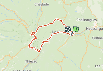
Puy Mary - Col du Pertus

PhilippeC54
User

Length
68 km

Max alt
1587 m

Uphill gradient
1801 m
Km-Effort
92 km

Min alt
882 m

Downhill gradient
1801 m
Boucle
Yes
Creation date :
2024-08-07 07:13:47.438
Updated on :
2024-08-07 19:24:30.248
4h05
Difficulty : Difficult

FREE GPS app for hiking
 SityTrail
IGN / Geographical institutes
SityTrail Plus
The world is yours!
About
Trail Road bike of 68 km to be discovered at Auvergne-Rhône-Alpes, Cantal, Murat. This trail is proposed by PhilippeC54.
Positioning
Country:
France
Region :
Auvergne-Rhône-Alpes
Department/Province :
Cantal
Municipality :
Murat
Location:
Murat
Start:(Dec)
Start:(UTM)
489114 ; 4994317 (31T) N.
Comments